© 2026 Roger Fontaine, Designed by Bison Software

Metalman9
M
E
T
A
L
M
A
N
9


M
E
T
A
L
M
A
N
9


Ph: 204-223-7809
METALMAN9
Ph: 204-223-7809
METALMAN9
Click the date link, then a photo to start larger photo gallery & see descriptions

May 10, 2023 - Reconnaissance Trip and Surface Finds
May 10, 2023
Reconnaissance Trip and Surface Finds.
Let’s
take
a
road
trip.
It’s
a
beautiful
day
out
and
the
fields
are
calling.
What
do
you
think
Tess.
Oh
and
let’s
bring
the
dogs
too…
and
away
we go.
This
reconnaissance
trip
involved
scouting
out
3
different
locations.
The
main
objective
was
on
River
Lot
#
151
deep
in
the
heart
of
the
Red
River
Valley.
All
sites
involve
later
metal
detecting
opportunities
and
of
course
new
adventures,
pictures,
stories
and
posts
so
stay
tuned to the Meatlman9.ca website for the latest.
River
Lot
151
is
the
second
lot
in,
off
of
Road
12,
the
first
correction
line.
(See
References).
It’s
wedged
in
between
Lot
#
150
and
152
and
it’s
worked
by
the
present
day
landowners
all
as
one
large
field.
My
objective
was
to
mark
its
boundaries
with
small
flags
in
an
effort
to
locate
and
mark
the
general
area
of
two
buildings
that
were
shown
to
be here on the 1870 survey map.
Lesson
No.1
It
looks
small
and
manageable
on
the
map
and
on
Google
Earth
but
man,
when
you
actually
get
there
and
have
boots
on
the ground and look around… this area is huge.
I
should
know
better.
This
is
not
the
first
time
that
I’ve
done
this
to
myself.
So
let’s
call
this
a
challenge
and
I’m
calling
in
the
troops.
I’ll
be
back
in
two
days
with
two
detector
friends
and
the
three
of
us
will
have
a go at this area and see what kind of history we can dig up.
While
scouting
and
planting
flags,
I
also
marked
any
surface
finds.
These
are
items
that
are
simply
seen
without
the
use
of
a
metal
detector.
I
picked
them
up
and
ended
up
with
quite
an
interesting
haul.
And,
looking
at
where
all
of
the
flags
are,
it
gives
me
a
good
idea
as
to
where
metal
detecting
will
be
at
its
best.
Surprisingly,
it
doesn’t
appear
to
be
where
the
two
buildings
once
stood
although
this
is
still
preliminary.
The
surface
finds
do
look
quite
promising
and
two
pieces
specifically
look
very
old
indeed.
This
is
the
pottery
piece
and
the
glass
with
the
mottled
look.
I’m
guessing
mid
to
late
1800’s.
It’s
always
nice
to
find
glass
and
ceramic.
It’s
a
telltale
sign
of
habitation.
The
big
square
iron
piece
weighs
in
at
4
lbs
plus.
The
odd
grayish
looking
piece
of
metal
had
me
puzzled.
It’s
not
super
old
as
there
is
some
hard
dry
weathered
black
plastic
tightly
stuck
to
it.
It’s
non-magnetic.
It’s
only
once
cleaned
that
it
gave
up
its
secret.
That’s
when
I
saw
the
“Plus”
sign.
It’s
a
battery post and a piece of the battery case. Now that’s cool.
I can’t wait till Friday to see what the day brings.
Ref:
https://laureenmarchand.com/2016/05/20/correction-line-principle/


May 12, 2023 - A Group Hunt on River Lot 151
May 12, 2023
A Group Hunt on River Lot 151
Good
friends,
good
weather
and
a
bit
of
organization
made
for
a
successful
hunt.
Randy,
Monty
and
I
all
had
a
lot
of
fun.
It
doesn’t
get
any better than this.
What
peaks
everyone’s
interest
with
River
Lot
151
was
the
discovery
of
3
previously
unknown
buildings
as
seen
on
the
1870
survey
map.
There
was
no
collective
memory
of
their
existence
or
any
visible
signs
on
the
ground.
Surveyed
were
3
buildings,
one
we
assume
to
be
the
living
house,
the
other
two
probably
barns.
There
was
also
a
large
parallelogram
shape
that
is
indexed
as
a
“Cultivated
Area”.
Interestingly,
one
of
the
buildings
actually
sort
of
sits
over
top
and
in
between
two
river
lots.
Remember
that
these
buildings
would
have
been
built
prior
to
any
official
survey.
Talk
about
encroaching
onto
your neighbor’s land.
The
eastern
end
of
these
river
lots
are
also
home
to
the
Pembina
Trail
that
wound
its
way
from
the
Red
River
Colony
(Winnipeg)
to
Fort Pembina in what is now North Dakota.
Now
what
became
very
interesting
and
revealing
were
the
utility
marking
flags
that
we
posted
wherever
we
found
an
artifact.
I
planted
some
two
days
prior,
where
I
picked
up
surface
finds
during
a
reconnaissance
trip.
See:
(
May
10,
2023.
Reconnaissance
Trip
and
Surface Finds
).
Now,
with
3
detectorists
on
the
go
all
at
once,
the
flags
eventually
created
what
I
think
is
a
telling
pattern.
Also
interesting
was
the
complete
lack
of
artifacts
where
the
3
buildings
were
shown
to
be
standing.
The
concentration
of
iron,
glass,
ceramics,
brass
and
other
items
were
all
in
the
first
100
feet
west
of
what
the
locals
refer
to
as
the
Old
14,
a
road
that
runs
north
and
south
along
the
Red
River.
Practically
no
artifacts
were
found
on
the
land
east
of
this
road;
between
the
Old
14
and
the
Red
River.
Whatever
few
items
that
were
detected
further
west,
100
feet
and
onward
were
mostly
more
recent
agricultural
machine
parts.
Very
few
nails,
square
or
otherwise
were found anywhere unlike on homesteads.
The
flags
mark
the
finds.
They
flanked
the
old
highway
from
north
to
south
direction
and
only
on
one
side.
My
conclusion:
these
artifacts
are
remnants
from
years
of
human
traffic
along
the
original
Pembina
Trail.
Most
of
the
glass
seems
to
have
come
from
various
bottles.
None
of
the
flat
window
pane
glass
that
is
often
associated
with
homesteads
was
found.
The
ceramic
came
from
dishware
like
cups
and
dishes,
and
a
gorgeous
piece
of
cast
iron
came
from
a
cooking
pot.
Three
hand
tools
were
also
found.
I
did
get
quite
the
laugh
when
I
uncovered
the
big
square
shaped
nut.
Anyone
familiar
with
the
reality
show
“BattleBots”
will
immediately
see
the
link...
Yes,
I
won
the
Big
Nut
award
that
day.
The
gold
colored
aluminum
“Cordoba”
piece
is
the
emblem
found
on
a
car
made
by
Chrysler.
And
just
for
a
second… one of the crew thought he’d struck it rich.
Of
even
older
origin
was
the
one
first
nation’s
hammer
stone
or
stone
axe
found
way
out
in
the
field,
far
from
the
road.
The
front
end
is
badly
damaged
which
is
probably
why
it
was
left
behind
and
abandoned,
oh
so
many
years
and
decades
and
maybe
even
centuries ago.
These
are
the
joys
of
metal
detecting.
It’s
discovering
a
little
bit
of
history every time you go out.
Roger
Reference:
https://battlebots.com/
https://en.wikipedia.org/wiki/Chrysler_Cordoba
http://www.mhs.mb.ca/docs/sites/fortdaer.shtml


May 22, 2023 - A Site with a Lot of History
May 22, 2023
A Site with a Lot of History.
Rivers
and
streams
were
the
lifeblood
of
most
all
activity
back
in
the
days
of
the
early
explorers
and
voyagers
and
pioneers.
The
Red
River
was
one
of
the
highways
to
the
Red
River
Colony
(Winnipeg).
The
Red
River
had
many
tributaries,
one
of
them
being
the
Marais
River.
So
named
by
the
early
French
explorers
signifying
Marsh
or
Swamp.
The
original
indigenous
inhabitants
lived
nearby
and
the
Marais
provided
water,
food,
wood
and
all
of
the
necessities
for
life.
The
Marais
can
still
be
followed
today
all
the
way
back
to
the
Morden
Hills;
the
escarpment
that
forms
the
west
side
of
the
Red
River
Valley.
It’s
near
this
river
junction
where
the
French
explorer
La
Jemmeraye was buried in 1736. The area is rich with history.
Metal
detecting
on
the
north
side
of
the
Marais
at
the
river
junction
proved
to
be
exceptional.
Accompanying
me
today
was
seasoned
detectorist
Randy
Gerylo.
There
is
a
point
of
land
that
is
tucked
away
behind
the
Marais’s
last
meander.
It
starts
a
few
feet
above
the
river
water
line
and
rises
up
from
there.
There
is
a
bit
of
high
ground
between
the
meander
and
the
Red
River
and
that
is
where
we
uncovered
some
rather
rich
and
exciting
historical
artifacts.
Here,
listed
in
point
form
are
some
of
the
finds.
These
are
some
of
the
oldest that I have come across so far in Southern Manitoba.
How
many
of
these
artifacts
can
you
find
and
match
with
the
pictures?
•
Cast iron stove leg.
•
Harmonica parts.
•
Pewter cutlery or flatware handle.
•
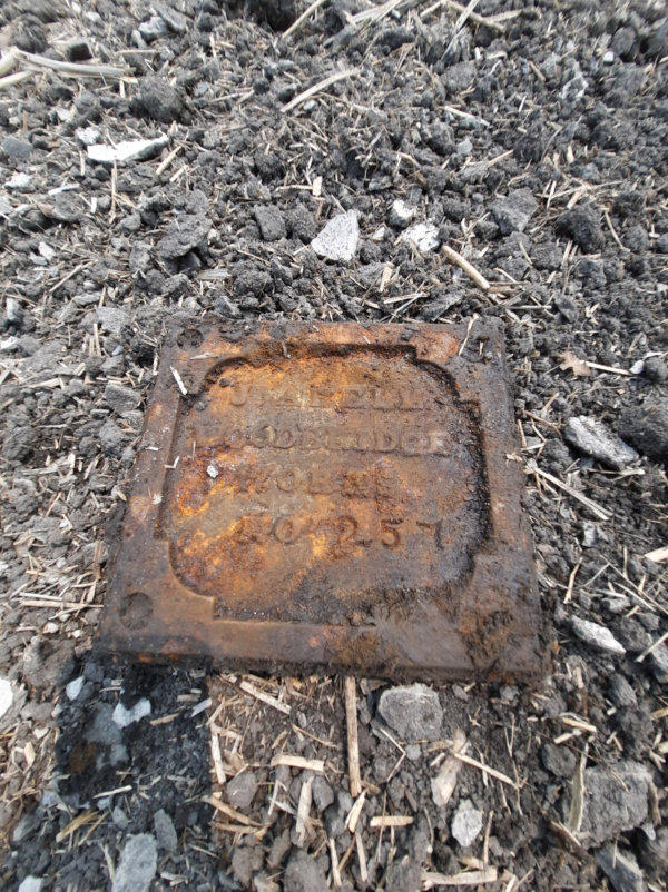
16
lb.
cast
iron
Steam
Tractor
identification
plaque.
Woodbridge
Works No. 257.
•
Door lock mechanism and copper strike plate.
•
2 US Pennies dated 1867 and 1917.
•
4” Rose Head Spike.
•
Buttons and leather grommets.
•
3 Tine fork shaft.
•
Religious Medallion dated 1850
•
22 gram and 1” long bullet plus multiple shell casings.
•
Copper spoon bowl, partial.
•
7 ½ “ Chisel.
•
Large “Baninedgington” grommet.
•
Pork Hock bones.
•
Brass “Mickey Mouse” wing nut.
•
Iron buckle
•
Huge 4” flat washer.
•
17 pcs. Lead. Usage unknown.
•
Fanciful Ceramic shards.
A
big
heartfelt
Thank
You
goes
out
to
the
land
owner.
By
allowing
a
couple
of
metal
detectorists
onto
your
property
you
have
opened
a
window
into
the
past
where
interested
people
can
see
and
appreciate
pieces
of
history.
Saved
are
a
few
remaining
artifacts
of
daily
life
back
in
the
mid
to
late
1800’s.
These
little
treasures
would
have
otherwise
been
forever
lost
to
time.
Now,
a
hundred
years
later,
and
then
some,
they
resurface
to
live
again
and
to
bring
joy
and
appreciation
to
a
new
generation
of
people.
Thank
you
from
Randy
and I and the numerous followers of this website.
Roger
R
e
f
e
r
e
n
c
e
s
:
h
t
t
p
s
:
/
/
w
w
w
.
c
b
c
.
c
a
/
n
e
w
s
/
c
a
n
a
d
a
/
m
a
n
i
t
o
b
a
/
l
o
s
t
-
i
d
-
bracelet-gimli-scotland-air-force-training-base-1.6375496
h
t
t
p
s
:
/
/
w
i
n
n
i
p
e
g
.
c
t
v
n
e
w
s
.
c
a
/
m
a
n
i
t
o
b
a
-
m
a
n
-
f
i
n
d
s
-
l
o
n
g
-
l
o
s
t
-
m
i
l
i
t
a
r
y
-
bracelet-on-beach-returns-to-family-of-scottish-pilot-1.5819194


May 28, 2023 - Following the Pembina Trail
May 28, 2023
Following the Pembina Trail.
There
it
is,
clear
as
day;
on
a
survey
map
dated
1870.
Right
there
between
River
Lots
153
and
160,
heading
south.
From
River
Lot
160,
the
Pembina
Trail
divides
into
3
clearly
marked
and
documented
branches
that
run
southward
yet
somehow
two
of
these
end
at
River
Lot
153.
I
say
“ends”
because
this
is
where
the
one
map
ends.
The
next
map
starts
at
River
Lot
152
and
there
is
no
continuation of these branches, just the one main trail.
Monty,
Randy
and
I
had
some
success
metal
detecting
between
River Lots 152 and 150.
(See:
May
12,
2023
A
Group
Hunt
on
River
Lot
151
).
I
have
a
theory
about
the
material
and
the
surface
finds
what
was
collected
there.
My
goal
today
is
to
see
if
I
can’t
replicate
the
same
results
along
one
or
two
of
these
three
Pembina
Trail
Branches.
I’ve
often
said
how
it
just
blows
me
away
that
I
can
detect
and
recover
a
bucket
full
of
metal
and
various
artifacts
in
a
field
where
there
has,
to
our
best
knowledge,
never
been
any
habitation
or
actual
homestead.
A
great
example
of
this
was
the
finds
from
a
hunt
last
year. (See:
October 29, 2022 The Recipe
).
The
field
looks
plain,
flat,
boring
even…
So
let’s
find
out
what
lurks
below.
Surface
finds
are
easy
in
a
tilled
farm
field.
It’s
relatively
easy
to
spot
ceramic
shards,
glass
and
yes,
even
metal
pieces
like
nails
and
farm
machinery
parts.
But
the
metal
detector
is
the
real
gem
here.
Not
only
does
it
alert
the
user
to
the
approximate
depth
of
an
item
but
the
detector’s
sound
also
alerts
you
to
different
metals.
Aluminum
and
copper
and
iron
all
have
distinct
sounding
tones.
I
just
can’t
help
but
get
excited
every
time
I
hear
one
of
those
high
pitch beeps.
Today,
I
was
on
Red
River
Lot
#
159,
between
the
Old
14
Highway
and
the
more
recent
#
75
Highway.
I’d
used
a
little
bit
of
math
by
way
of
cross
multiplication,
measurements
in
both
inches
and
centimeters,
old
maps
and
pictures
from
google
earth
and
I
mapped
out,
to
the
best
of
my
ability,
where
the
trail
and
its
branches
would
be
found
on
the
ground
today.
Once
on
the
field,
I
looked
for
the
higher
ground.
Yes,
land
contours
would
have
changed
some
from
153
years
ago
but
not
all
that
much.
Low
and
wet
areas
now
have
drainage
but
they
are
still
low
areas.
Trails
to
travel
on
would
have
followed
the
higher
ground
to
avoid
getting
stuck
in
mud,
the
same
high ground that I can see today.
Well
I
have
a
theory,
and
today’s
hunt
went
a
little
way
to
confirm
it.
I
am
hoping
to
locate
and
trace
out
the
trails
by
following
the
artifacts left behind by travelers long ago.
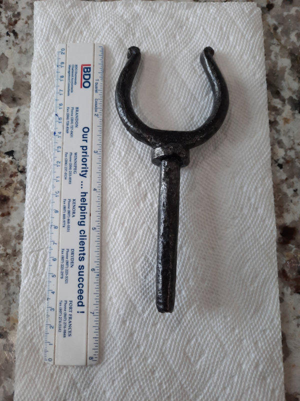
I
did
find
the
“Y”
looking
artifact
on
higher
ground
where
I
suspected
the
one
of
the
trails
to
be.
The
item
is
definitely
old
and
is
hand
forged.
And
unlike
the
finds
two
weeks
ago,
I
only
found
one
piece
of
glass
and
no
ceramic
shards.
These
always
indicate
human
presence.
The
buckle
is
brass,
is
also
old
and
was
found
on
or
near
the original Pembina Trail.
The
find
of
the
day
along
the
main
trail
had
to
have
been
the
silver
plated
piece
of
flatware
complete
with
the
Maker’s
Marks:
HB
CO
A
I
am
guessing
that
these
letters
might
stand
for
Hudson
Bay
Company.
The
“A”
well
I
don’t
know.
This
is
going
to
be
a
research
project.
Last
but
not
least
is
a
piece
of
geological
history.
There
are
3
rocks
and
a
back
bone
to
possibly
a
deer.
Two
of
the
rocks
are
sedimentary
in
nature;
the
other
is
a
smoky
quartz.
All
three
are
covered
with
a
layer
of
what
can
only
be
called
coral.
If
not
coral,
then
whatever
grew
on
rocks
at
the
bottom
of
Lake
Agassiz.
One
has
to
remember
that
long
before
anyone
lived
or
travelled
here,
this
entire
region
was
covered
by
the
Laurentide
Ice
Sheet,
and
then
came
Lake
Agassiz.
Remnants
of
the
lake’s
presence
are
quite
common
but
this
last
picture
is
a
great
example
and
evidence
of a long gone era.
Roger


May 28, 2023 - Habitation on River Lot 159
May 28, 2023
Habitation on River Lot 159.
May
28
was
a
busy
day.
The
preceding
article
is
from
the
same
outing.
I
took
some
time
in
the
afternoon
to
see
if
I
couldn’t
find
traveler
artifacts
on
the
opposite
side
of
the
Old
14
Highway
just
in
case
the
Pembina
Trail
had
run
more
on
the
east
side
than the west side of this road.
I’m
beginning
to
think
that
the
Old
Highway
was
built
pretty
much
right
on
top
of
the
trail.
It
would
be
a
logical
choice
as
it
was
more
than
likely
the
most
direct
route.
Just
like
off
of
River
Lot
149,
I
found
nothing
but
a
few
modern
round
nails
along
the
Old
14’s
east
side.
The
west
side
appears
to
be
where
it’s
at.
I
will
repeat
this
exercise
in
a
few
weeks
on
another
river
lot
just
south of here and we’ll see what that turns up.
I
then
turned
my
metal
detector
towards
the
river.
Last
year,
Monty
and
I
had
found
plenty
of
evidence
of
habitation
right
up
and
along
the
river
bank.
See:
October
22,
2022
-
Monty,
Myself
,
and
the
triangle
field
of
River
lot
#
159.
Wow…
this
area
did
not
disappoint.
In
fact
if
I
keep
finding
any
more
stove
top
parts,
I
might
be
able
to
reconstruct
it.
Well
maybe
not
but
clearly
people
lived
here.
I
found
more
of
these
stove
top
parts
the last time we were here.
Much
to
my
surprise,
and
it
took
my
big
shovel
to
dig
this
out,
but
laying
upside
down
at
about
8
inches
in
depth
was
a
7
lb
clothes
iron.
It
must
have
taken
a
lot
of
energy
and
strength
to
use this thing because it’s sooo heavy.
I
found
more
agricultural
machine
parts
of
course
and
a
nice
assortment
of
ceramic
and
yes,
porcelain
shards
too.
Two
of
the
ceramic
pieces
show
a
pattern.
Then
there’s
the
5
lb
iron
button.
Well
it
looks
like
a
button…
The
shotgun
shell
was
an
old
one,
the
type
that
used
paper/cardboard
as
packing
in
the
bottom
of
the
shell.
It
was
marked
No.
12
UMC
Co.
NEWCLUB . It dates Cir. 1896-1900.
Square nails abound too. A great place to metal detect.
Roger
Reference:
http://www.cartridge-corner.com/umc.htm


May 25, 2023 - A Paying Job
May 25, 2023
A Paying Job.
Late
in
the
evening
of
May
24,
2023,
I
received
an
email
from
a
local
contractor
seeking
my
services
as
a
metal
detector.
It
would
appear
that
a
landscaping
work
crew
got
maybe
a
little
over
enthusiastic
and
inadvertently
covered
up
a
water
sprinkler
valve
under
4
or
5
inches
of
topsoil
and
then
rolled
out
the
sod.
Yes,
that
is a predicament.
I
contacted
Chris
and
we
worked
out
a
fair
deal.
What
I
personally
like
to
offer
people
when
it
comes
to
the
recovery
of
lost
items
is
as
follows.
There
is
a
set
dollar
amount.
A
fee
if
you
will
for
just
going
out
and
searching.
This
is
meant
to
cover
my
gas,
my
time
and
the
use
of
my
metal
detector.
I
am
very
comfortable
spending
an
hour
or
so
detecting.
A
second
fee
is
then
added
if
I
am
successful
locating
and
recovering
the
said
lost
item.
I
feel
that
this
is
fair.
The
client
then
knows
up
front
what
the
dollar
amount
is
going
to
be
in
either scenario.
Chris
provided
me
with
a
street
address
and
a
location
of
where
on
the
property
this
water
valve
should
be.
We
both
want
to
succeed
in this endeavor so the more specific the location the better.
I
arrived
on
site.
It
is
in
a
brand
new
neighborhood
where
many
of
the
houses
are
not
yet
inhabited
and
many
are
in
various
stages
of
completion.
I
was
quite
surprised
that
Google
earth
even
listed
the
street
name.
I
posted
my
sign
on
the
address
lawn
“Metal
Man
-
Detectorist
at
Work
by
Permission”,
took
pictures
for
the
record
and
went to work… or should I say “Went Detecting”.
Three
separate
hits
sounded
on
the
front
lawn.
These
were
confirmed
with
the
Pin
Pointer.
I
did
not
dig
them
up
as
I
did
not
want
to
damage
the
newly
laid
sod.
Chris
or
one
of
his
employees
can
do
that.
I
marked
the
spots
with
utility
flags,
took
pictures
and
precise
measurements
of
these
three
locations,
emailed
Chris
the
information
then
packed
up
and
went
home.
Payment
arrived
later
by e-transfer. Ahhh… the beauty of modern technology.
It’s a great way to fund my hobby and have fun at it too.
Thank you Chris and Company for the work!!!
Roger